Agnieszka Dolatowska
(Adam Mickiewicz University, Poznan)
Andrzej Prinke (Poznan Archaeological Museum)
Danuta Prinke (Poznan Archaeological Museum)
Archives for the history of aerial archaeology
in
Central Europe
paper presented at the session "Historical Perspectives
on the Material Culture of Archaeology",
organized by AREA_III
Project
In
our paper we wish to concentrate on archives, as one of
the more multi-aspectual elements of the material culture
of archaeology. For our analysis we have selected the specific
problem of the comparison and assessment of the different
contexts of the oldest examples of the application of aerial
archaeology in European archaeology, in order to use this
as the background for the assessment of the value of Polish
archives and use them for the reconstruction of different
aspects of the history of Polish aerial photography. Information
illustrating the historical background to the development
of aerial archaeology has been collected on the basis of
the available literature. The characterisation of the Polish
example of the use of this technique, on the probably most
famous Polish archaeological site at Biskupin (an extensive
water-logged Late Bronze Age & Early Iron age settlement),
is based on the rich collection of archival materials which,
although it has been partially published, has never been
analysed from this point of view. |
In
the past few years one may observe a clear increase in interest
at aerial archaeology in Poland. In many centres (including
Poznan) attempts have been made to introduce a methodology
based on the best traditions of the British school. One
of the problems raised by Polish archaeologists involved
in aerial archaeology has been the determination of the
manner of development of this technique in Poland. This
has been caused by the "rediscovery" of Biskupin - together
with its unique collection of aerial photographs. |
| The first aerial photographs |
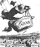
fig. 1 |
Modern
aerial archaeology combines the use of two great inventions,
the aeroplane and the camera. The first aerial photographs
however were taken before the invention of the aeroplane.
It is thought that the first aerial photographs ( fig.
1) were taken in October 1858 by Nadar (Gaspar Felix
Tournachonm) soaring in a balloon over Paris (Duel p. 21).
It is however a paradox, that the greatest advances in aerial
photography were connected with military activity, despite
the fact that this eminent photographic pioneer refused
to help the military intelligence services in 1859 during
the war |
| with
Austria. War and the preparations for it played
an important stimulating role in the origin and development
of aerial photography. It was used by the military for the
first time in the Civil War in the United States of America
(Bewley, p. 11). |
| The oldest aerial photographs of archaeological sites |
The
greatest development of aerial archaeology took place during
the First and Second World Wars; the first steps in this
direction however were taken already before 1914 and were
connected with the use of military balloons. In 1906 in
the course of exercises with military balloons, Lieutenant
P. H. Sharpe took the first aerial photographs (both vertical
and oblique) of an archaeological site, in this case the
famous megaliths of Stonehenge ( fig. 2).
In 1908-1911 Italian engineers photographed the Forum Romanum
and also the harbour at Ostia (Duel, p. 23-4). In 1912 a
site thought to be a Roman fort was photographed from a
balloon |
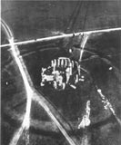
fig. 2 |
by Kurt May and his friend Reinhard,
but excavations carried out soon afterwards showed it was
in fact a Roman villa (Bewley p. 12). If however the number
of aerial photographs taken in 1914 could be counted in
the dozens, by the end of the First World War the Royal
Air Force alone had taken about half a million (Rączkowski
p. 31). |
| The First World War and aerial photography |
From
several points of view, the First World War was the turning
point. The introduction of the aeroplane opened practically
unlimited scope of observation from the air. The War effort
created conditions for the rapid improvement of the construction
of aeroplanes, flying techniques and aerial intelligence
gathering. This also affected photographic equipment, such
as cameras, lenses and film. |
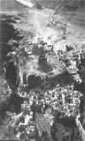
fig. 3 |
The
possibilities of the use of aerial photography for archaeology
were perceived by a number of people serving during the
First World in the Near East, the eastern parts of the Mediterranean
basin and the northern parts of Africa. Here the remains
of the past are still much more easily visible and there
are better conditions for aerial photography. It was in
these regions that the most famous pioneers of archaeological
aerial photography were active: Antoine Poidebard, Jean
Baradez, Léon Rey (France), Theodor Wiegand (Germany) ( fig.
3), G. A. Beazeley, and Sir Aurel Stein (Great Britain)
(Bewley, p. 10). |
Apart from these people, at that time
other archaeologists (amateurs) had their first experience
with aerial photographs while engaged in military cartography,
intelligence and the air-force (both as pilots as well as
observers) in military service in different regions of the
world in which fighting was taking place. It may therefore
be said that the War not only was the stimulus for the development
of the equipment used in the taking of aerial photographs,
but also for the development of reflection on the subject. |
| Great Britain - the birth of a method |
The
experience gained by the pioneers of aerial archaeology
during the First World War led to the formulation of the
principles and the propagation of the technique. It is generally
accepted that the person who brought this about was Osbert
Guy Stanhope Crawford ( fig. 4), a
trained geographer, who, in the initial phases of the War,
served in the section preparing and updating maps used for
military |
fig. 4 |
| purposes (he was a geographer by training).
In 1917-1918 he served as an observer in the Royal Flying
Corps. During some of his flights over German positions
in France and Germany, he identified some features he spotted
as archaeological sites (Rączkowski, p. 46). After the end
of the War he began to use the experience he had gained
in the analysis and interpretation of aerial photographs
from the point of view of their potential use as a source
of knowledge about the past. In 1923 Crawford delivered
a paper to The Royal Geographical Society on Air Survey
and Archaeology - a paper published twice in 1923 and
1924 as the first description of this new technique.
Crawford's activities
led to a growth of interest in aerial photography among
his contemporaries (G. P. M. Insall, G. W. G. Allen, C.
E. Curwen, D. N. Riley). Their work led to many discoveries,
and also deeper reflection on the technique of aerial photography
and the photointerpretation. Another effect of their activities
was the creation in Great Britain of an approach to the
possibilities of the use of aerial photographs, which differed
from, that which may be observed in the two decades between
the World Wars on the continent. |
The
pioneers of German aerial archaeology (Wiegand and Schuchhardt)
took aerial photographs in the Near East and in Romania
already in the First World War. The defeat of Germany in
1918 however hindered the development of this technique.
Despite this, military photographs are known of archaeological
sites (for example Roman roads) from Bavaria, which were
taken in 1916 - 1918. They are currently preserved in the
military Archives of the Bavarian Museum in Munich.
An obvious increase
in archaeological interest in aerial photography occurred
in the 1930s. In this period, most of the sites photographed
were those with an obvious form in the landscape, such as
the earthworks of strongholds. After 1935 there was a wider
use of aerial photography in archaeology and flights were
carried out in a more planned way. A number of investigators
turned to divisions of the Luftwaffe with requests to carry
out aerial photography of specified archaeological sites.
As a result of this situation, in 1937 an agreement was
signed between the Ministry of Aviation and the Ministry
of Science and Education in order to initiate collaboration
between pilots and archaeologists. The Minister of Aviation
declared that he would support the idea of the taking of
aerial photographs of archaeological sites during training
flights.
One of the effects
of this agreement was the planned participation of cadets
from the flying school at Hildesheim in the excavations
of the royal seat at Werla (Saxony) built in 916 for Heinrich
I (fig. 5, 6).
Thanks to the aerial photographs taken during these investigations,
it was possible to discover architectural remains, and also
determine the exact limits of the site. These photographs
were the basis for the planning of the excavations of the
1937 season. Another result of the 1937 agreement was the
visit of O.G.S. Crawford to Berlin in 1938. Both archaeologists
and pilots were present at this meeting with the "father
of aerial archaeology" at the so-called "evening of lectures".
The papers presented at this meeting were later published. |
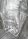
fig. 5 |
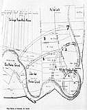
fig. 6 |
The
first aerial photographs of archaeological sites from the
area of the present Czech Republic and Slovakia are known
from 1929 and 1931. As in the majority of the countries
of central Europe however there were only a few flights
organized by archaeologists and art historians. The result
was the creation of a small collection of oblique photographs
which (as in the case of the photographs of Biskupin) only
illustrations of archaeological sites (Gojda 1993, p. 869). |
The
history of Polish aerial photography in the period of interest
here (1918-39) is rather modest, and one of the most important
episodes is connected with the site at Biskupin mentioned
previously. |
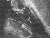
fig. 7 |
The
earliest archaeological aerial photographs of an archaeological
site in Poland were taken by pilots from the marine aviation
corps in Puck in 1929. These were photos of the settlement
site excavated by Józef Kostrzewski at Rzucewo (Okupny p.
215). The settlement itself cannot be seen on these photographs,
which show its general location and geomorphological setting
( fig. 7). This event however did not
have any lasting consequences for Polish archaeology. |
Only
the systematic taking of aerial photographs during the investigations
carried out at the spectacular site at Biskupin had an effect
on the interest in this topic. The experience gained by
the authors of these photographs was utilized in the taking
of similar ones ( fig. 8) during the
excavation of the early medieval stronghold at Kłecko (Poznan
area), where Wojciech Kóčka took a series of photos (Rączkowski
p. 22). |
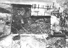
fig.
8 |
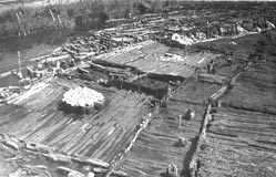
The
collection of photographs taken at Biskupin from a variety
of types of balloons was supplemented by photographs taken
from aeroplanes. Beginning in 1935, pilots of the third
aerial division from Poznan and the fourth aerial division
from Torun carried out several training flights over Biskupin
during which oblique photos of the Biskupin peninsula (fig.
9, 10) and
its surroundings (fig. 11) were taken
together with photos of several other stronghold earthworks
in the same region, as well as the historic centres of Gniezno
and Poznan, where excavations were being conducted (Okupny,
p. 218, 224). |
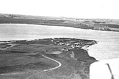
fig. 9 |
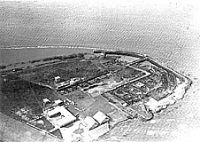
fig. 10 |
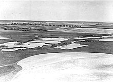
fig. 11 |
It
is worth pointing out that a number of contemporary Polish
archaeologists were aware that there was a need for the
wider application of this technique on the same lines as
in British archaeology. This was expressed for example in
a number of popular articles, presenting the British achievements
(Jażdżewski 1938 - ZOW). |
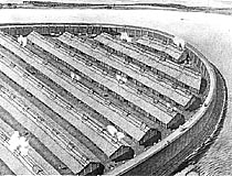
Biskupin,
in Gąsawa commune to the east of Poznan, is a wooden fortified
settlement ( fig. 12) of the Lusatian
Culture of the Hallstatt period (c. 700 BC), discovered
by chance in 1934. It was situated on a swampy island, which
the builders had strengthened with a breakwater of several
rows of wooden piles ( fig. 13). It
was surrounded by a frame-built timber wall 3m thick, and
the interior was regularly built-up with parallel rows of
similar-sized buildings (fig. 14,
15). |
|
fig. 12 |
fig. 13 |
|
fig. 14 |
fig. 15 |
Our
knowledge of the site is based on the results of investigations
carried out in the years 1934-1939 by an expedition from
Poznan University led by Józef Kostrzewski. It is worth
emphasizing: |
| - |
the unparalleled spectacular
nature of these discoveries seen against the background
of the contemporary state of northern European archaeology,
|
| - |
their modern nature especially
the interdisciplinary manner in which the investigations
were carried out and an awareness of the need for the most
precise manner of documentation possible in that period
(including the method of aerial photography), |
| - |
the awareness of the need
to protect the uncovered remains and the reconstruction
for the modern visitor, |
| - |
schooling of archaeological personnel. |
It is not possible today to assess the significance
of the discovery of this site nor the value which was attached
to the excavations (in the organization and promotion of
which were involved the highest state and ecclesiastical
authorities), without taking into account the contemporary
historical and political context of Poland and the main
currents of discussion carried out by archaeologists entangled
in contemporary concerns. Some elements of this atmosphere
can be reconstructed and illustrated on the basis of the
preserved archival photographs. |
1/ The real archaeological
dimension. The fact of the discovery of this site and especially
the modern style and tempo of the excavations and their
documentation were an undeniable success of Polish archaeology
on an international scale ( fig. 16),
and this is evidenced by: |
| - |
the rank and
number of visitors who made a 'pilgrimage to the site' incl.
president, cardinals, generals, excursions etc.) about 500
000 people (of which half were foreigners) visited Biskupin
in the period 1935-1939, |
| - |
participation in exhibitions,
shown in many museums in Europe and the USA, |
2/ The extemporaneous ethnic argument
in the conflict over the contemporary political situation
of the region. Biskupin lies in the eastern fringes of Great
Poland, one of the larger regions of Poland in the history
of which the relationship between the neighbouring Poles
and Germans played a significant role ( fig.
17). In the period of the Partitions, when there was
no Poland on the map of Europe, this region was in the Prussian
partition. The discussion over the "Slavicness" or "Germanness"
of these lands was conducted at many levels. Biskupin was
announced to be a "Prehistoric Slavic stronghold", thus
putting an end to debate on this topic.
3/ The real social-political dimension: In order to make
its mark in Europe, the young state (which came into existence
only in 1918 after 120 years absence from the maps of Europe)
needed to have real successes in every field of activity. |
The
scale of the investigations at Biskupin is reflected in
the photographic material in the archives preserved in the
archaeological museum in Poznan, which - assessed in detail
- allows several types of analysis. In the next part of
our presentation, we will use this material as illustrative
material and in particular we will show material concerning
aerial photography. The material preserved in the archives
of the Archaeological Museum in Poznan comprises: plans,
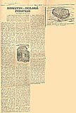
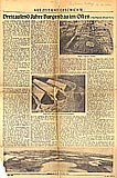
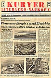
a folder of press cuttings (fig. 16,
17, 18), and
- of most interest to us here - a full series of |
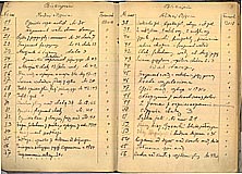
fig. 19 |
the photographic documentation
(scientific and occasional) of the excavation campaigns,
together with the original inventory ( fig.
19), containing descriptions of the subjects of all
the photographs taken. This collection contains 2 300 photographs,
of which 150 are aerial photographs of the site and other
100 are photographs which document the application of various
techniques and the atmosphere that accompanied them. |
| Aerial Photography at Biskupin |
The
use of aerial photographs for the purposes of documentation
during the investigations at Biskupin on the one hand emphasizes
this unique position of Biskupin in Polish archaeology,
and on the other, the use of this technique (and others)
was probably possible only because of the exceptional status
of the discoveries made at this site. |
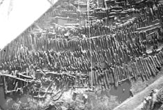
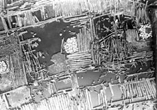
The
aerial photographs taken at Biskupin primarily constituted
documentation of the discovered constructions. The extensive
size of the explored area forced the use of this method,
since photographs taken from ground level were inadequate
(because they were too oblique), while those from a ladder
( fig. 20) could cover an area only
40 metres square.
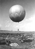
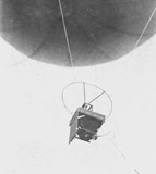
In 1935 two assistents
of Kostrzewski - Zdzisław Rajewski and Wojciech Kóčka,
|
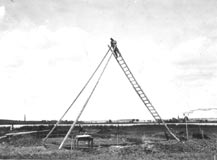
fig. 20 |
designed a small spherical balloon
of a diameter of 3m and filled with 23m 3 of hydrogen which
gave a lift of 3.5kg ( fig. 21). The
design of this balloon was based on that of one used in
1929 to take vertical photographs of buildings at Megiddo
in Palestine. The Biskupin balloon was tethered ( fig.
22) and was used to take vertical views of the site
from heights 5 - 150 m (it was not possible to achieve greater
heights because of the weight of the steel tether used).
The line was fixed to two hand-operated windlasses. The
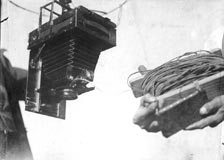
shutter of the camera suspended below the balloon was released
with an electric mechanism ( fig. 23)
connected by a wire with a battery on the ground. After
each exposure the balloon had to be brought back to earth
to change the plate, the photos were taken on 9x12 and 13x18
cm glass plates (Okupny, p. 216-8). |
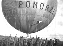
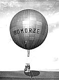
Another
means of supporting the cameras utilised in the expeditions
at Biskupin from 1937 was a large tethered military observation
balloon with a basket for the camera crew (fig. 24,
25). The appearance of this equipment
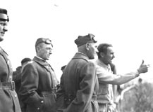
at Biskupin was the effect of the visit (fig. 26)
to the excavation in September 1937 of the Polish Marshal
Śmigły - Rydz (Rajewski 1938, s.9). From this balloon photos
were taken with a hand-held camera on 9x12 cm glass plates
from the heights of 50 - 110 m, the photographs encompassed
therefore a considerably greater area of the investigated
structures than those taken from the small balloon (Okupny,
p. 218). Photographs were also taken from the basket of
a free-flying balloon (fig. 27),
which the members of the expedition flew from Biskupin to
Stargard in 1936. It was a propaganda stunt, and the crew
(fig. 28) threw information leaflets
about Biskupin from the balloon. |
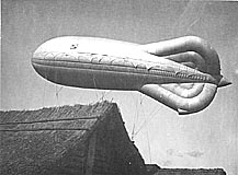
fig. 27 |
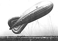
fig.28 |
Aerial
photographs were also taken in later excavations in 1946-1947,
but it was impossible to continue this in subsequent years.
This carefully
conceived, designed and efficiently executed action resulted
in several hundred aerial photographs of excellent quality.
These were utilised many times in archaeological publications,
as well as in popular literature and propaganda material
concerning the discoveries at Biskupin, and also shown in
exhibitions, including ones abroad. Before 1939, the Poznan
archaeological milieu and in particular the Biskupin expedition
was the only one in Poland in which such photographs were
taken and which do not differ in any way from the best British
ones of the period. Unfortunately a significant proportion
of the negatives were lost during the Second World War,
but happily a complete series of prints has survived in
the archives in Poznan, but they have never been analysed
or published in their entirety (Okupny, p. 224). |
The
quality of the aerial documentation has allowed the main
aim to be reached - the aerial photographs constitute an
objective record of the discoveries give new generations
of investigators the possibility of reaching their own interpretation
of the site at Biskupin, and allow the verification of the
original field documentation left by the excavators and
the veracity of reconstructions based on them. |
| Archives for aerial photographs in central Europe. |
In
summary, it may be said that the general picture of the
development of the technique of aerial photography in this
region in the two inter-War decades is very modest in comparison
with Western Europe. Apart from the episodes described above,
there is a lack of other evidence documenting the use of
this method, and the picture is even worse in Eastern Europe.
One may seek the causes of such a situation in several factors:
1/ Lack of tradition : - the countries of Central Europe
were mostly reborn new states which had not previously possessed
a technical infrastructure (aeroplanes) nor access to areas
with spectacular ruins which had so fascinated the pioneers
of these techniques.
2/ In the case of Poland - not enough interest among the
archaeological milieu in the cognitive possibilities of
these methods for them to become widely applied, even when
the technical ability was present. This is shown by the
multi-aspectual collaboration between archaeologists and
the military in the course of the excavations at Biskupin,
or the earlier collaboration with the air-force at Rzucewo.
It was not possible for us to verify whether or not permanent
collaboration could have been established, as was the case
in Great Britain or Germany. Would a young and weak state
, in the tense political climate of the times, have permitted
access to aerial documentation of large areas? |
| A few further reflections |
Aerial
photographs are used for various purposes in different aspects
of life and at different periods of the history of every
country, beginning at its birth. One might say that even
if they were not created for the purposes of archaeology,
they exist in numerous archives of various types and document
information also of interest to archaeologists. This information
is to a greater or lesser degree subject to secrecy, but
the older the photos are, the greater is the possibility
of access to larger areas of coverage, which are uncensored.
It should be clearly stated that the development of this
technique was largely halted after the Second World War
for political reasons. Nevertheless the quality and priceless
nature of the information contained in some of these photos
can be demonstrated by photos taken in the 1950s for cartographic
purposes and still having the status of "secret".
At the end we
may add the encouraging thought that almost every country
in the region discussed here has its own archaeological
aerial records, all that has to be done is to rediscover
it and bring it out of the secret archives... |
| Bewley R.H. |
| 1997 |
From military to civilian: A brief history of the early development
of aerial photography for archaeology, (in:) Oexle (ed.)
, Aus der Luft - Bilder unserer Geschichte: Luftbildarchäologie
in Zentraleuropa, Dresden, pp. 10 - 21 |
Deuel L. |
| 1984 |
Lot w przeszłość, Warszawa |
Gojda M. |
| 1993 |
Bohemia from the air:
seven decades after Crawford, Antiquity, v. 67, no.
257, December, pp. 869 - 875 |
Guy P.L.O. |
| 1932 |
Balloon Photography and
Archaeological Excavation, Antiquity, v. VI, no.
22, June, pp. 148 - 155 |
Jażdżewski K. |
| 1938 |
Lotnictwo na usługach prehistorii, Z otchłani wieków, vol. XIII, pp. 33 - 41 |
Kowalenko W. |
| 1938 |
Grody i osadnictwo
grodowe Wielkopolski wczesnohistorycznej (od VII do XIII
wieku), Poznań |
Okupny B. |
| 1998 |
Fotografia lotnicza w
archeologii. Uwagi metodyczne. (in:) Śmigielski W. (ed.),
Nauki przyrodnicze i fotografia lotnicza w archeologii,
Poznań, pp. 215 - 244 |
Rajewski Z. |
| 1938 |
Sprawozdanie z organizacji
prac w Biskupinie w pow. żnińskim w latach 1938-39, (in:)
J. Kostrzewski (ed.) , Gród prasłowiański w Biskupinie
w powiecie żnińskim. Sprawozdanie z badań w latach 1936
i 1937 z uwzględnieniem wyników z lat 1934-1935, Poznań,
pp. 1 - 14 |
| 1950 |
Sprawozdanie z organizacji
prac w Biskupinie w pow. żnińskim w latach 1938-1939 i 1946-1948,
(in:) J. Kostrzewski (ed.), III Sprawozdania z prac wykopaliskowych
w grodzie kultury łużyckiej w Biskupinie w powiecie żnińskim
za lata 1938-1939 i 1946-1948, Poznań 1950, pp. 1 -
11 |
Rączkowski W. |
| 2002 |
Archeologia lotnicza - metoda wobec teorii, Poznań |
| Figures: |
Fig. 1 Nadar (Gaspar Felix Tournachon),
Paris, 1858
Fig. 2 P.H.Sharpe, Stonehenge, 1906
Fig. 3 Theodor Wiegand, Palmyra (ca 1914-18)
Fig. 4 Osbert Guy Stanhope Crawford
Fig. 5 1937, Luftwaffe Flying School in
Hildesheim Werla (Saxony, Germany)
Fig. 6 Site plan
Fig. 7 1927, Maritime Air Division, Rzucewo
(Gdańsk voiv.)
Fig. 8 Kłecko, balloon photo taken from
50 metres
Fig. 9 Biskupin Peninsula from SE (no. 942)
Fig. 10 SW part of Biskupin Peninsula -
photo taken from a plane (no. 945)
Fig. 11 Surroundings of Biskupinskie Lake
- Bembenek's field (no. 968)
Fig. 12 Reconstruction of the stronghold
(made by Bryndza; no. 1072)
Fig. 13 Breakwater - balloon photo taken
in 1935 (no. 322)
Fig. 14 Huts and circuit street alongside
the NE defences (no. 1045)
Fig. 15 Row of huts between two transversal
streets (no. 729)
Fig. 16 Article from the Prague newspaper
"Svobodny zirtek"
Fig. 17 Article from Krakauer Zeitung (Nazi
Occupation Daily)
Fig. 18 Press cutting from Kuryer Literacko
- Naukowy
Fig. 19 Original (field) photo index
Fig. 20 Taking photos from the ladder (no.
621)
Fig. 21 Balloon above the excavation area
(no. 790)
Fig. 22 Balloon with a camera (no. 595)
Fig. 23 Balloon camera (no. 589)
Fig. 24 Balloon with Polish flag ready
to flight (no. 870)
Fig. 25 Rise of "Pomorze" balloon (no.
853)
Fig. 26 Dr. Rajewski shows Biskupin to
the Marshall Smigly-Rydz - commander-in-chief of the Polish
Army (no. 892d)
Fig. 27 Dirigible balloon (zeppelin) above
the museum (no. 869)
Fig. 28 Dirigible balloon (zeppelin) above the site (no. 935) |
|